Informing within-field fertiliser management from satellite data
Spatial information on crop nutrient status is central for monitoring vegetation health, plant productivity and managing nutrient optimization programs in agricultural systems. Due to the strong correlation between nitrogen and chlorophyll content in crop species, it is possible to use chlorophyll content as a relative indicator of plant nitrogen status.
This study uses Landsat-8 OLI data (30 m) to map the spatial variability of leaf chlorophyll content within wheat (Triticum aestivum) and corn (Zea mays) fields, with differing quantity of nitrogen fertilizer application. This research provides an operational basis for modelling within-field variations in leaf chlorophyll as an indicator of plant nitrogen stress, using multispectral data within a physically-based modelling approach, and opens up the possibility of exploiting a wealth of satellite data and lightweight multispectral imagers on UAV platforms.
This study uses Landsat-8 OLI data (30 m) to map the spatial variability of leaf chlorophyll content within wheat (Triticum aestivum) and corn (Zea mays) fields, with differing quantity of nitrogen fertilizer application. This research provides an operational basis for modelling within-field variations in leaf chlorophyll as an indicator of plant nitrogen stress, using multispectral data within a physically-based modelling approach, and opens up the possibility of exploiting a wealth of satellite data and lightweight multispectral imagers on UAV platforms.
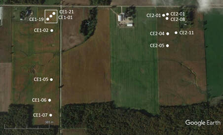
Locations of sampling sites within two corn fields. White box denotes zero fertilised application.
|
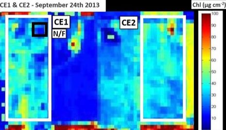
Modelled leaf chlorophyll content for two corn fields. Black box denotes zero fertilised application.
|
For more information: Croft, H. Arabian, J. Chen, J.M. Shang, J. and Liu, J. (2019) Mapping within-field leaf chlorophyll content in agricultural crops for nitrogen management using Landsat-8 imagery. Precision Agriculture, 1-25
